Features
Business & Policy
Research
Our precious water
Farming potatoes or any other crop is about understanding and managing many important elements in a sustainable way. Soil, crop protection products, plant genetics, fertilizer, weather, water – farming is about using the latest science and technologies relating to these factors to make sure we have a great harvest, while at the same time doing our best to protect the environment.
June 10, 2013 By Treena Hein
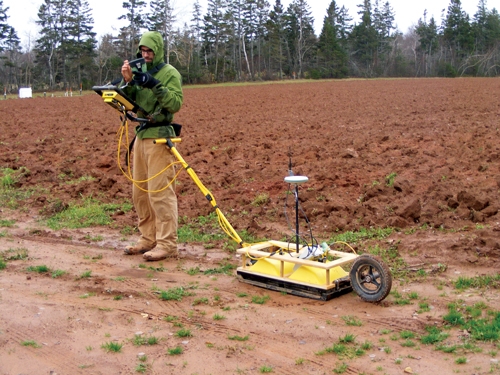 Dr. Serban Danielescu conducts a ground penetrating radar survey to measure water quality in New Brunswick’s potato belt. Farming potatoes or any other crop is about understanding and managing many important elements in a sustainable way.
Understanding water quality issues in the Black Brook Watershed, in the heart of the potato belt in northern New Brunswick, is the work of Dr. Serban Danielescu, a hydrologist based at the AAFC’s Potato Research Centre (PRC) in Fredericton who has a joint appointment with Environment Canada (EC) and Agriculture and Agri-Food Canada (AAFC). His quest to protect water quality in agricultural areas while helping farmers stay productive is part of a long-term collaboration between AAFC and EC, one that brings together leading researchers from inside and outside government.
The team includes PRC colleague and fellow hydrologist Sheng Li, and others from the University of New Brunswick (UNB), the Eastern Canada Soil and Water Conservation Centre, Nova Scotia Agricultural College, and the New Brunswick government. “We are aiming to provide the best possible tools for decision-makers, including farmers, on which practices can be used to best protect water quality,” Danielescu says.
Collaboration between the various organizations involved in water research is common in Canada. “It provides significant advantages by leveraging resources and building on common needs,” he says. “It also helps secure the right technical support and scientific expertise.” Interdisciplinary teams are also best, because they are able to tackle the complexity of ecological systems and the multifaceted nature of environmental issues, adds Danielescu.
To gather information on soil, thickness of subsurface layers, bedrock configuration and depth to the water table, Danielescu is using ground-penetrating radar (GPR), a non-invasive, relatively inexpensive method. “Integrating GPR into this groundwater research is being achieved through collaboration with Dr. Karl Butler from the Department of Earth Sciences of UNB (Fredericton), who is an expert in using and developing geophysical methods for engineering, environmental and exploration applications,” Danielescu explains.
The information is used to set parameters and develop computer models of groundwater movement – a large factor in water quality. The models produce representations of the groundwater flow and transport of chemicals in the subsurface environment. “Models can be developed at different scales and have various levels of complexity, depending on your research objectives,” Danielescu notes. They vary in approach and can represent the physical environment into one, two or three dimensions, and can extend from one site (such as one farm field) up to the scale of a watershed.
“In my research, the models are important tools for looking into the interactions between groundwater and surface water, and for understanding the impacts of various contaminants – for example, excess nitrogen leaching from agricultural operations on aquatic ecosystems,” he explains. “Some of the models I use allow for the tracking of flow amounts and the fate of contaminants from the moment the precipitation reaches the ground and infiltrates in the soil, until the groundwater is discharged to streams and further reaches coastal waters.”
While Danielescu uses complex programs available for modelling groundwater flow and transport, he also built his own more simplistic models that can be developed and used with the capabilities of a standard office workstation and minimum software requirements.
Computer modelling and more
In the first step of creating a model, the spatial aspects are defined using topographical and geological information from GPS surveys, satellite imagery and maps. Once defined, the model domain is then filled with site-specific data that can come from site surveys (for example, physical properties of the bedrock such as porosity and permeability), monitoring (for example dynamics of groundwater levels, weather conditions) and sampling (nitrogen concentrations in groundwater, for example). “In the next step,” Danielescu explains, “the model is calibrated to make sure the data it produces is acceptably close to the actual site conditions.” This model can then be used in different scenarios – for example, what happens if fertilizer use is reduced, or rain patterns change?
Other than ground-penetrating radar and computer models, Danielescu also employs other technologies. “I use pressure transducers for continuous monitoring of groundwater levels, and dielectric sensors for measuring electrical conductivity, water content and temperature above the water table,” he says. “I also use things like borehole camera video surveys for investigating particular features in the substrate and wells.”
He and his team also collect water and bedrock core samples using conventional equipment, such as specialized submersible pumps and drilling rigs with diamond coring capabilities, and then analyze the samples for chemical composition and physical properties using specialized instruments and other resources.
Other methods not traditionally used for groundwater research also sometimes need to be used. “For example, naturally-occurring stable isotopes of nitrogen (N) and oxygen from nitrate present in water are used to detect where N in groundwater came from, based on the fact that various N-containing compounds have specific signatures,” Danielescu explains. “Nitrogen-based fertilizers have a different signature than organic wastes. Similarly, naturally-occurring hydrogen and oxygen isotopes of water are used to identify whether the water we have sampled is from rainfall, subsurface flow or some other source.”
Danielescu has also used a novel approach centred on airborne Thermal Infrared Radiometry for quantifying groundwater discharge into coastal areas. It involves using an airplane-mounted infrared camera to map the contrast between cold groundwater water plumes mixing into warmer estuarine water.
Danielescu’s research into surface water interactions and the sources and fates of nutrients in groundwater addresses both AAFC and EC priorities – enhancing the environmental performance of the Canadian agricultural system, and preserving and enhancing the quality of our environment, specifically aquatic ecosystems.
“Once my research has been published in reports or peer-reviewed journals,” he adds, “the results can be used by various departments and organizations to adapt current regulations and policies, change environmental management practices, identify science gaps or establish new research directions.”
In terms of how research such as his impacts the typical potato farmer, Danielescu recognizes that individual farmers face “the difficult challenge of balancing out long-term economic and environmental sustainability versus immediate net returns” in their use of crop protection products, fertilizer and so on.
“To this effect, farmers must build up a tremendous amount of information ranging from market pressure and climate variability to rock solid science,” he says. “As scientists we only hold a piece of the puzzle.”
Print this page